A first version of the web-based mapviewer was presented at the GeoUtrecht – the annual geoscientific conference of the German Geological Society (DGGV). In contrast to the common approach, this time the national meeting was jointly organized by DGGV, KNGMG and the University of Utrecht (www.geoutrecht2020.org) and virtually held from 24th to 26th of August. The next annual conference is called GeoKarlsruhe – Sustainable Earth – from processes to resources and will be held from 19th to 23rd September 2021 in Karlsruhe (Germany).
The mapviewer is one of MEET’s deliverables that were designed to foster the upscaling and promotion of the local-scale findings from analogue and demo-sites. It is dedicated to fill the gap between national geothermal viewers provided by several European countries and the huge variety of freely available geoscientific, environmental, economic, social and engineering geospatial data at European or even global scale. In the future, the webviewer can be used as a tool to find, to compare, to combine and to utilize large-scale geodata, which are highly relevant for geothermal activities. Furthermore, it can be also used as a pathway to lead future users from large-scale geodata to national web-based solutions.
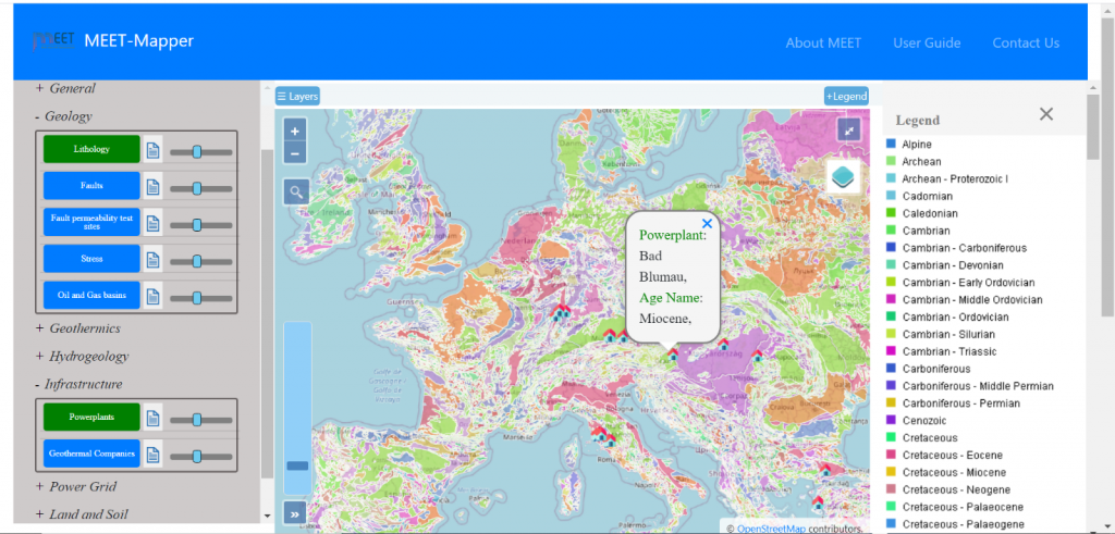
The mapviewer, which is based on solutions, such as OpenLayers, PostGIS and GeoServer, combines and provides freely available geodata at European scale. The geodata are selected due to their relevance for geothermal undertakings, but also on their availability and quality. Although the team is aware of the limitations and heterogeneity of geodata covering Europe, at the recent stage the categories “General”, “Geology”, “Geothermics”, “Hydrology”, “Infrastructure”, “Powergrid”, “Land and Soil” and “Environment” are already populated with one or more layers. In the figure below, these main categories and some associated layers are visible on the left side. The layer “Lithology” (based on the European geological map) is overlain by the layer of existing geothermal plants in the central map window. For more information about the concept of a Geographic Information System (GIS), please check the following article: What is a Geographic Information System?
The feedback to the presentation, which was given in the session “Working on the roads: improving the infrastructure for research into-geosocietal challenges” hosted by Ronald Pijnenburg and Kirsten Elger, was very positive. Furthermore, among the wide variety of topics in this inspiring session, major data infrastructure platforms and projects at European scale were presented, such as EPOS, EGDI, INSPIRE and GIP-P within GeoERA. On the one hand, all of them host geodata that are partly relevant for the geothermal viewer. On the other hand, they are evaluated as potential long-term hosts of the webviewer after the end of the MEET project. In one of the next steps, the communication and interaction with their geospatial experts will be deepened.
Beside the clarification of the webviewer’s future, the upcoming tasks are the integration of petrophysical, geochemical, hydrogeological and radiogenic heat production datasets, the provision of sample data from the MEET’s demo sites and the implementation of calculation tools.
In parallel, the possible linkages between the webviewer and the decision-making tool will be discussed within the project consortium.

Fig 1: Screenshot of the web-based mapviewer showing the combined visualization of the “International Geological Map of Europe and adjacent Regions 1:5.000.000 (IGME5000)” (BGR) as well as the “JRC Geothermal Power Plant Dataset” (Documentation, EUR 29446 EN, Publications Office of the European Union, Luxembourg, 2018, ISBN 978-92-79-97264-5, doi:10.2760/203858, JRC113847).
On the left-hand side, further main categories and associated layers are visible. On the opposite side, a detailed legend of the IGME5000 is shown.
For further information, please contact:
Dr. Bianca Wagner (bwagner1@gwdg.de) or Richu Mary Shelly (richumary.shelly@uni-goettingen.de), University of Goettingen, Geoscience Centre, Germany


